Founded by the Romans in 197 BC, Salerno was long sought after by the Goths and Byzantines, and it was eventually conquered by Lombards in 552; it was later annexed to the duchy Of Benevento in 646. When in 849 the duchy was divided into two separate principalities, Salerno became the capital city of one of them. However, the Lombard domination was weakened by the death of prince Guaimario IV who was murdered in 1052; Robert the Guiscard sieged the city in 1076 and the entire principality went under Norman control.
After a period under the Swabians, in the XIV century Salerno was conquered by the Sanseverino Princes and in the XV century it witnessed the war between Angevins and Aragonese. In 1656 Salerno was severely hit by the plague, which more than decimated its population; furthermore, there were two devastating earthquakes in 1688 and 1694. Only in the second half of the 1700 Salerno had finally recovered, and after the Italian unification in 1861 it was among the most industrialized provinces in the country thanks to the development of textile factories, and it experienced a solid socio-economic growth.
AMALFI COAST AND CAPRI
- amalfi coast
- Salerno
- Cetara
- Amalfi
- Positano
- Sorrento
- Capri
- Atrani
- Maiori
- Minori
- Ravello
- Vietri sul mare
Tab 1
AMALFI COAST AND CAPRI
Surrounded with magic and dream… among places of such a rare beauty, colors, charm and traditions that have inspired artists and poets from all over the world. It is impossible not to be captured by the vision of unique scenarios, a jagged coastline rich of history and legends, and hidden beaches only accessible from the sea.
THE CLIMATE
In these places the climate is always mild. Temperatures rarely go below 8/10 C°. Spring and Summer - up until October - are the best periods of the year for sailing here.
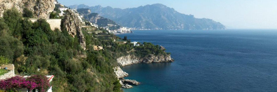
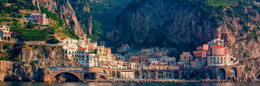
The Amalfi Coast, magically suspended between the blue sky and a clear turquoise sea, is one of the 50 Italian sites inscribed in the UNESCO World Heritage List. Located in the southern coast of the Sorrentine peninsula, it overlooks the Tyrrhenian sea and the Salerno Gulf, and it is delimitated by Positano on the West and Vietri sul Mare on East. Named after the city of Amalfi, this stretch of coast is famous all over the world for its nature, a unique Mediterranean scenario with high natural and cultural value, and due to its topographic characteristics and historical evolution.
This is a stretch of coastline where there is a sequence of promontories and coves, bays and fiords, spaced out by pebbly beaches and cliffs, on the top of which Norman sighting towers stand - a testimony of the attempt to defend native populations from the Saracens attacks. The mountain’s crests have been terraced for centuries, and are now cultivated with olive trees, grapevines and lemon trees. The terraced gardens with lemon trees are typical of this area. The lemons of the Amalfi coast are sweet, slightly bitter and with a round taste; they are called ‘pane,’, bread, because they can be eaten slice by slice as a dessert, or used for the famous limoncello, an aromatic bright yellow liquor with an amazing lemon aroma.
The Amalfi coast spreads for 11.231 hectares and in includes 16 municipalities -all of which belong to the Salerno province- a succession of villages enclosed in the rocks, connected by the panoramic SS.163 road built during the Bourbons’ domination in the first half of the XIX century and nowadays considered one of the most beautiful roads of the country. Among the places that are worth visiting:
Amalfi, the little town that gives its name to the coastline, rich of history and culture, was the first of the four Maritime Republics and it controlled for a long time the maritime commercial traffic with the East. The Duomo di Sant’Andrea, with its spectacular staircase, the Arabic-Norman bell tower, and the fascinating Chiostro del Paradiso (Heaven’s Courtyard) are among the most visited monuments in the coast.
Atrani, the smallest village in Europe, with its beautiful churches of San Salvatore del Birecto and of Santa Maria Maddalena, is like a natural amphitheater that overlooks the sea, offering a fascinating and unique panorama to its visitors.
Cetara, a small fishermen burg, specialized in the fishing of anchovies and tuna, is popular for its typical cuisine that includes the famous anchovies sauce ‘colatura d’alici’.
Conca dei Marini, with its beautiful and unique cave ‘Grotta dello Smeraldo’, is hometown to the typical dessert ‘sfogliatella di Santa Rosa’, that was baked for the first time, according to tradition, on its cliffs overlooking the blue sea.
Furore, with its famous fiord, dug during the centuries by the Schiato stream, it is also known as the painted village because of its original en plain air artistic graffiti.
Maiori, with its wide beach, the ‘Collegiata di Santa Maria’ on the seaside and the San Nicola de Thoro Plano Castle, was known as Reghinna Major, and in the second half of the XX century it became one of the neorealist film director Roberto Rossellini’s favorite locations.
Minori, the old Reghinna Minor, formerly used as summer residence by the Romans, is famous for its production of handmade pasta. Surrounded with verdant gardens, the small town has beautiful architectonical gems, like the remains of a maritime Roman villa that goes back to the I century, the Basilica of Santa Trofimena.
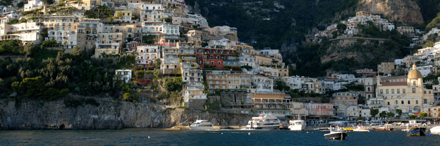
Positano, the pearl of the Amalfi coast, an elite and fashionable location, is one of the most popular places in the area. Positano was used, like Minori, as summer residence by the Romans. Its white small houses that descend towards the sea, the small shops and the many narrow stairs make it a unique place. Long appreciated by artists and VIPs, Positano is famous for the artisan production of leather sandals and cotton and linen clothes (Moda Positano), for its antique buildings and the breathtaking view of the dome of the Chiesa dell’Assunta covered in mosaics, facing a deep blue sea and the Li Galli isles.
Praiano, where the princes of Amalfi used to spend their holidays, offers a unique and quite atmosphere. The belvedere of the church of San Luca and San Gennaro will surprise the visitors with an unforgettable view.
Ravello, the town of music, is popular for its cathedral, the fascinating Villa Cimbrone and Villa Rufolo and the Oscar Niemeyer Auditorium, located at 350 m from the sea level. Ravello also hosts an important music festival that every year embraces and celebrates all artistic disciplines.
Scala, the oldest village in the Amalfi coast, is the hometown of brother Gerardo Sasso, the founder of the Order of the Knights of Malta.
Tramonti, a small town located on the hills of the Amalfi coast, in engulfed by the verdant nature of the Lattari Mountains. It is the ideal place where to try out the typical cuisine, among chestnut woods and vineyards.
Vietri sul Mare is known all over the world for the production of brightly colored ceramic tiles. Vietri’s suburb, Albori, has been listed as one of the most beautiful burgs in Italy.
Tab 2
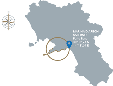
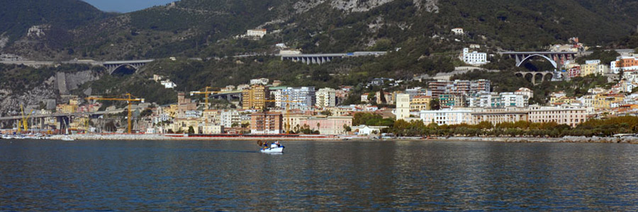
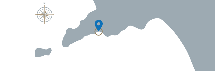
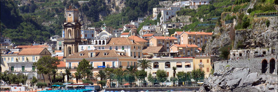
Salerno
If you would like to take advantage of the Salerno based catamaran, you can visit the city – taking a walk on the seafront and then entering the fascinating historical city centre.
The Duomo dedicated to St. Matthew and its crypt are definitely worth a visit. The Duomo was commissioned by Robert the Guiscard in 1080, and it is a masterpiece of arab-norman art. The cathedral has two basilicas with a nave and two aisles, an upper one and a lower one. The lower basilica holds the crypt, where in 1081 the remains of St. Matthew were deposed. St. Matthew is the patron saint of the city and of all martyrs from Salerno as well. The crypt is simply spectacular: an example of baroque art, with cross vaults, it contains frescos and mosaics of rare beauty.
The Arechi castle, a medieval building, deserves a visit as well, even just for the breathtaking view it offers. In fact, it stands on the top of the Bonadies Hill, overlooking the entire city of Salerno. The castle was built around half of the 8th century, and it was commissioned by the Lombard prince Arechi II when Salerno became capital of the Duchy of Benevento.
Another amazing view can be admired from the Giardini della Minerva, which can be reached through an escalator. The gardens are famous for growing officinal herbs at the time of the ancient Salerno Medical School.
Feast Days: The day in which Salerno celebrates its patron saint St. Matthew is September 21st. On that occasion, a religious procession takes place, ending with the typical race up to the top of the Cathedral stairs.
Tab 3
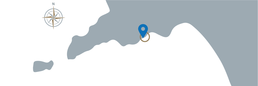
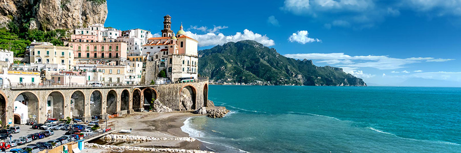
Cetara
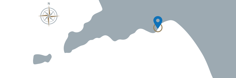
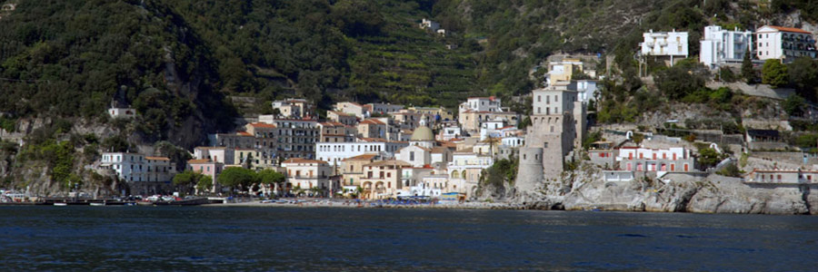
Cetara is a small fishermen village, and it dates back to the middle ages. It was founded in the IX century, when the Saracens moved here and established a colony. Cetara was then annexed to the duchy of Amalfi, and it took part in the duchy’s marine and commercial activities with the rest of southern Italy, northern Africa and the Byzantine Empire. Since 1030 it was ruled by the Amalfi Archbishop, who started imposing taxes on fishing. Later on it became part of the Amalfi Republic; the inhabitants of Cetara were since then believed to be the best fishermen of the entire coast. In the XII century a still existing sighting tower was built, which became fundamental for defending the area from the Ottomans in 1543. That tower is still today the symbol of the village. In 1833, Cetara became once again an independent town. It is famous for its ‘tonnare’.
The spectacular Torre Vicereale dominates the entire coastline. This tower dates back to the Angevin domination, but it was later modified by the Aragonese. It was partly rebuilt in 1800. Today, it hosts the Museum of the Sea.
The Chiesa di San Francesco with its courtyard and other Franciscan buildings were built at the end of the XIV century. Inside the church, in the single nave, there are several important frescos. Once in the village, we recommend to stop and take a look at the traditional small shops dedicated to anchovies and tuna fish preservation, which is still today the main activity in Cetara. Once there, you can have lunch and try the spaghetti with anchovy sauce (colatura d’alici), the traditional plate of the village.
Here are the beaches you can find in the first part of the Amalfi Coast, between Vietri and Cetara:
La baia
You can find this pebbly beach in the heart of the village of Cetara. Its charm is mainly due to the surrounding historical buildings, but also the shops and small restaurants where you can have typical meals.
La Crespella
This beach is very small, and consequently usually overcrowded, but it will amaze you with a perfect view of the Faraglioni rocks and the old Saracen tower.
Marina di Vietri
This cliff offers an amazing view of the Faraglioni rocks and I Due Fratelli rocks; you can find bars, restaurants and bakeries close by. Seaside establishment on one part of the beach will make your stay here even more comfortable and enjoyable.
Marina di Albori
The village of Albori, with no more than 350 inhabitants, is one of the oldest burgs in Italy, lost between the sea and the mountains. Its traditional stone houses with dome roofs, stairs and narrow roads will lead you to three fascinating beaches.
Marina di Cetara
A small beach can be found behind the Cetara bridge, and it dates back to the 1980 earthquake. It overlooks the Collata bay, and offers a seaside establishment that can be reached by car.
Lido Portuense
n this pebbly and sandy beach you will enjoy fresh sea breeze throughout the day, thanks to its strategic position right behind the port in Cetara.
Spiaggia Lannio
Spiaggia Lannio is a sandy beach located right before Cetara; it was named after the laments of the local monks killed by the Saracens. The beach is characterized by the presence of flat rocks, and there is a small café right at the beginning of the shore.
The small port in Cetara is made of a dock 141m long and an outer pier with two arms 250m long.
Dangers: pay attention both on your way in and out because of an underwater barrier.
Access Time: continuous.
Beacons and Lights : 2630 (E 1729.1) - red flashing light, 3 sec., 6 M range on the top of the outer pier; 2630.3 (E 1729.12) - green flashing light, 3 sec., 3 M range on the top of the inner pier.
Sea bed: sand.
Depth: piers 3,50 to 4,30 m; in port 5,80 to 8,50.
Radio: vhf channel 16 (canale Salerno).
Moorings: 50.
Maximum length: 13 m.
Winds: N, SW, SE.
On shore wind: SE.
Nearby safe anchorage: Salerno port.
CETARA
40°38', 81 N 14°42', 27 E
Feast Days: on June 29th, the day in which Cetara celebrates its patron saints St Peter and St Paul, various events take place, at the end of which you can enjoy fireworks by the sea. On July 22nd, instead, on the Tuna Festival, people from all over the province come to Cetara to try its food specialties.
Food Specialties: Anchovies and tuna fish are the most typical foods, and are typically preserved in many different ways (under oil, under salt, sundried etc).
Tab 4
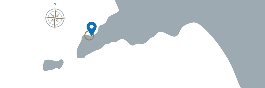
Amalfi
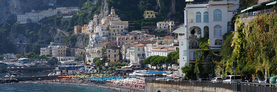
The origins of the town of Amalfi are uncertain; it seems likely, however, that it was first founded by the Romans who sheltered there while escaping from the German and Lombard invasions, the town was later employed as a fortress during the domination of the Byzantine duchy of Naples. Amalfi was one of the four Italian Maritime Republics in the IX century, and it controlled the local maritime commercial traffic while developing trade relations with nearby populations. In 1039 the town was besieged, and fell under control of prince Guaimaro V and Robert the Guiscard afterwards. Amalfi was conquered in 1131 by the Norman king Ruggiero II, thanks to whom the town managed to reflourish. Amalfi was the heart of the maritime traffic of southern Italy during the middle ages, and its famous mercantile fleet managed to stop the Arab attempted invasion. The XI century Republic arsenal is still in Amalfi today, and it testifies the power and strength of the town back in medieval times. Foreign domination after domination Amalfi was weakened, and it only recovered in 1800, when Joseph Bonaparte and Joachim Murat ordered to build a road to connect the town and nearby villages to Naples.
La cattedrale di Sant’Andrea. This cathedral is an arab building with a spectacular staircase and two basilicas, an older one that dates back to the VI century, and a more recent one that was built in the IX century.
Il Chiostro del Paradiso. The Courtyard is characterized by lancet arches typical of the arab-norman art, and by six chapels with frescoes from the 1300.
L’Arsenale. Once employed for war ships building, today it hosts a Museum that opens everyday in summer from 10am to 8pm.
Le Cartiere e il Museo della Carta. Among the oldest paper mills in the area, the Cartiera Amatruda and the Paper Museum are located right before the Valle dei Mulini.
Marina Grande
In the heart Amalfi, Marina Grande is one of the most famous beaches in the coast, loved by tourists from all over the world. It offers a long but usually crowded beach, with seaside establishment that will make your stay more comfortable and enjoyable.
Castiglione
This is the marine hamlet of Ravello, an old medieval town, famous for the panorama offered from the sandy beach. It is surrounded by more than 100m long cliffs that can be reached through a 186 steps staircase that connects the beach to the Statale Amalfitana road, where you can get by car or public transportation. There is one seaside establishment and two free beaches that are lit by sunlight up until the first hours of the afternoon.
Ha un unico stabilimento balneare e due zone libere assolate fino al primo pomeriggio.
Atrani
An high wall of rocks encircles the small village of Atrani and its small beach that is only 130m long. It will take not more than one day to visit the old centre and to spend a few hours in one of the seaside establishment on the sandy shore. Atrani can be easily reached by car or public transportation.
Duoglio
This pebbly beach is one of the most beautiful places of the entire coastline. Only 1km far from Amalfi, it can be reached by climbing a 400 steps staircase. There are two seaside establishments, one of which, the ‘Lido degli Artisti’, lends water sports equipment (e.g. scuba diving, windsurfing and canoeing).
Santa Croce
This beach was named after the Chapel dedicated to the Holy Cross, whose remains are still located there. The shore is lit by sunlight since the first hours of the morning, and it is famous for its clear blue sea. It can be accessed from sea.
Between Amalfi and Positano you can find the Praiano beaches, which range from the narrow Furore fiord to the Gavitella beach.The small Furore beach is one of the most typical places of the entire coastline. It is lit by sunlight only in the afternoon, and it is accessible from the sea or through a long and steep staircase. Right after Furore you will find the Marina di Praia bay, a narrow pebbly beach enclosed by rocks on the three sides, where a panoramic path will take you to the Saracen tower. The Gavitella beach, thanks to its disposition facing west, offers an amazing view of Capri and Li Galli and it is one of the few places on the coast where you can enjoy sunlight up until sundown. The beach also offers a famous restaurant located in the middle of the shore, a perfect place for a romantic dinner. It is accessible from sea or through a steep staircase.
The Amalfi port is protected SW by an outer pier 190m long, and E by an inner pier (east pier); between the eastern side of the pier and a new one you can find a touristic dock which is not accessible at the moment.
Dangers: it is dangerous to moor in the port in presence of strong winds from the I and II quadrants; there are mooring buoys nearby quays.
Access time: 8am to 8pm.
Access: Access is permitted after 8pm only to those who are already familiar with the port; proceed with caution (max speed 3 knots) giving precedence to vessels on their way out. Vessels equipped with vhf must contact the Maritime Authorities.
Beacons and lights: 2620 (E 1718) - red flashing light, 5 sec., 2 M range on the top of the outer pier; 2624 (E 1720) - green light, 2 verticals, 3 M range, on the top of the east pier.
Sea bed: sand and mud.
Depth: pier 2 to 6 m.
Radio: Vhf channel 16 - 12.
Moorings: 300 among which 3 for transit only.
Maximum length: 30 m.
Winds: NE in winter, SSE in summer.
On shore wind: NE.
Shelter: outer pier sheltered by west wind and mistral; inner pier sheltered by grecal.
Nearby safe anchorage: when in presence of bad weather conditions from S and SE, it is recommendable to move toward the Salerno port, because the Amalfi port is not protected in the I and II quadrants.
AMALFI
40°37',94 N 14°36',13 E
Feast Days: The Historical Regatta of the Maritime Republics takes place in Amalfi as well as in the other three former republics (Genoa, Pisa and Venice). Before the regatta, there are usually a flag-waving show together with an historical parade. Such event evokes the glorious past of the town, in an atmosphere full of charm and joy.
Typical Products: The typical product of Amalfi is the limoncello, a lemon flavoured liquor.
Tab 5
Positano
Positano has extremely old origins. Archeologists have discovered remainings that date back to the stone age; but we know that during the Greek classical period the town was not inhabited. Just like Amalfi, Positano flourished under Roman domination.
The structure of the town in unique; it developed vertically, and it is full of typical buildings, small shops and restaurants, and the narrow streets will take you from the highest part of the town to the beach and its spectacular blue sea.
Apart from its beautiful shores, the crowded Marina Grande and the hidden and more reserved Fornillo and Laurito, Positano definitely deserves a visit for its typical buildings and small shops.
The beautiful Chiesa di Santa Maria Assunta has a dome entirely covered in mosaics, while inside the church you will find a more classical style, with ionic columns and capitals in gold. Here is located the Black Madonna with Child, a Byzantine masterpiece of the XII century.
From the sea, it is possible to look at the numerous Saracen towers, once employed to catch sight of enemies and protect the land from invasions.
Marina Grande is the most well-known and crowded beach in Positano. From here you can see Li Galli islands, and opposite the beach there are the typical brightly colored houses of the burg.
From Positano it is possible to reach many other beaches, by walking on the paths or by sea. The closest beach is Fornillo, accessible through a path among the cliffs that starts right from the quay; this beach is certainly less crowded and it is particularly popular among younger people.
Laurito is a small beach that can be reached from the Hotel San Pietro piazza, through a staircase. This small but precious beach has an hotel and restaurant right in front of the sea.
The Arienzo beach, as well, can be accessed through a long staircase. This is where the sun goes down the latest in the afternoon, and a lot of people come here for an aperitivo to enjoy this incredible atmosphere.
In the large Positano bay there is a quay, an iron jetty (where hydrofoils and motor vessels employed for passenger transport can moor) and a beach. It is advisable to moor in the roadstead, around 300/400m far from the Marina Grande beach (depth 25/30m), opposite to the town; give precedence to vessels employed for passenger transport; avoid mooring in waters nearby the mooring pier.
Dangers: at the moment the quay is only practicable for 38ml, designated for the mooring of hydrofoils and motor vessels employed for passenger transport.
Access Time: continuous.
Access: give precedence to vessels employed for passenger transport.
Sea bed: sand.
Depth: pier 0,5 to 2,5 m.
Radio: vhf channel 16.
Moorings: 150 on mooring buoy
Maximum length: 20 m.
Bans: it is prohibited to moor on pier, it is only allowed to come close enough to permit embarking and disembarking of passengers.
Winds: S, SE.
On Shore Wind: II and III quadrants.
Nearby safe anchorage: Salerno port and Amalfi port.
POSITANO
40°37',63 N 14°29',10 E
Feast Days: On June 15th, Positano celebrates its patron saint St. Vito. During the week before the 15th, a lot of events and religious processions take place in town.
Typical Products: Handicraft and textiles are the most typical and characteristic products you can find in Positano. The famous local fashion, Moda Positano, consists of light clothes made of cotton and linen.
Tab 6
Sorrento
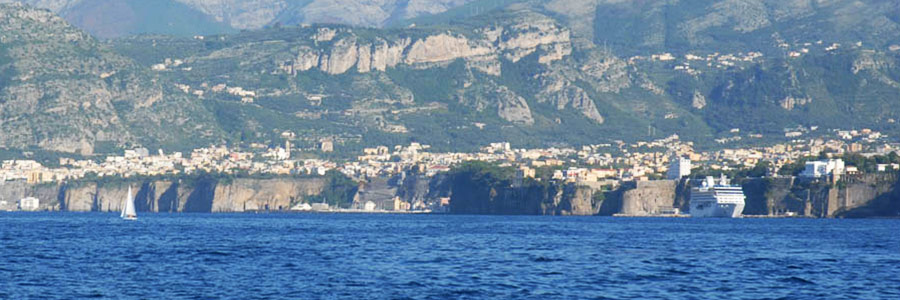
The origins of Sorrento are uncertain, but it seems the town dates back to ancient times, since archeologists have discovered Etruscan artifacts that are now located in the Museo Correale. The Greeks laid out the still existing structure of Sorrento; after the Greek period the town was conquered by the Oscans, the Romans, then the Byzantines, the Lombards, the Normans and the Aragonese. Sorrento was afterwards sacked by the Turks in 1558, and after this episode the town was fortified and sighting towers were built. Today Sorrento is rich of important buildings and it is famous for its beautiful villas. It was the birthplace of Italian author Torquato Tasso, and because of its undeniable beauty, it was chosen for the filming of various movies (for example, ‘Pane, amore e…’ with Sophia Loren and Vittorio de Sica).
La Cattedrale. The cathedral is dedicated to St. Philip and St. James and it was built in the XV century. The romanic building has a famous renaissance lateral gate, and in its aisles we can find paintings by the most important artists of the Neapolitan School of 1700.
La chiesa di S.Francesco and its courtyard with cross arches made from tuff, all go back to the VIII century.
Palazzo Veniero, built in the XIII century, is a late byzantine and arabic building.
Spiaggia di Ieranto
This is one of the most incredible beaches of the entire coastline. It is a sandy and pebbly beach surrounded by spontaneous mediterranean vegetation; the sea water is incredibly clear, and the view of the Punta Campanella lighthouse and the Faraglioni rocks simply breathtaking. There are no seaside establishments.
Marina di Cassano
Located in the old fishermen burg, the volcanic Marina di Cassano beach is only a few km far from Sorrento. The access is only possible by climbing long and steep stairs. The shore has seaside establishments but also free-access beaches. In addition, there is a small port with a long pier for yachts and the mooring of fishing boats. Near Marina di Cassano you can find small restaurants and cafès.
Marina di Vervece (Massa Lubrense)
Massa Lubrense is a small maritime burg enclosed by a long cliff. Here it is possible to play water sports, such as canoeing, windsurfing, sailing and scuba diving. It is highly recommended to dive into the Vervece cave, whose rocks are full of life. Descending until 12m you will be able to admire the Vervece Madonna, a bronze statue, the protector of scuba divers.
I bagni di Regina Giovanna
I Bagni della Regina Giovanna is a natural rocky beach located on top of Sorrento. We advise you to wear comfortable shoes to walk on this beach. A wooden staircase allows the access to a turquoise sea water swimming pool, surrounded by rocky walls covered by brightly colored Scotch broom. A natural arch makes the water fall directly into the open sea.
The Sorrento port is made of an outer pier with two arms oriented toward NE-ENE, a quay and an inner pier.
Orario di accesso: continuo.
Access Time: continuous
Access: vessels on their way in and out of the port will have to proceed at minimum speed, making sure they are avoiding to generate waves within the port. Other vessels, including yachts and motor fishing boats that are navigating near ships must proceed at the minimum speed as well, keep themselves at a safe distance and should a dangerous situation arise, they must be ready to take preventive measures to guarantee the safety of those onboard. Even in a non-dangerous situation, speed within the port cannot exceed 5 knots.
Beacons and Lights: 2588 (E 1698) - green light, 3 sec., 5 M range, on the top of the quay.
Sea bed: sand.
Depth: pier 1,8 m to 7 m.
Radio: Vhf channel 09 tourists port; 16/13 Locamare Sorrento.
Moorings: 280.
Maximum length: 40 m.
Bans: it is prohibited to swim and to fish within the port.
Winds: II quadrant.
On shore winds: NO.
Shelter: IV quadrant.
Nearby safe anchorage: Marina di Meta.
Marina Piccola – SORRENTO
40°37',83 N 14°22',70 E
Feast Days: On February 14th Sorrento celebrates its patron saint, St. Antonino Abate - on the same day people from all around the world celebrate being in love!
Food Specialties: The lemons from Sorrento are used in the making of many different traditional plates and desserts. In addition to the limoncello, we recommend the Delizia al Limone, a pastry made with lemon flavored cream and limoncello.
Tab 7
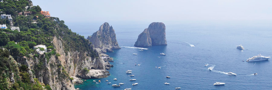
Capri
As for the rest of Campania, the history of Capri has always been influenced by socio-economic and political changes in the Mediterranean region. Here archeologists have discovered stone age artifacts, but it was only during the Romans domination that Capri started to flourish. Emperor Augustus and Emperor Tiberius both built here numerous villas.
Capri’s Grotta Azzurra is famous all over the world because of the incredible color of its waters; the hidden beaches, the Arco Naturale and the fascinating coastline make this island unique.
The island is still today a mix of history, culture and high society. Taking a walk in the famous Piazzetta is a must, and we also highly recommend to visit Villa Jovis, the summer villa of Emperor Tiberius, that stands from the eastern hills of the island. Another villa that is worth visiting is Villa San Michele, on the north-east of Anacapri, from which you can admire one of the most beautiful views that Capri offers. It was built by Axel Munthe on an ancient Roman villa, where there was a chapel dedicated to St. Michele. Today it houses a museum, where the public can admire the head of Medusa that used to adorn the Venus Temple in Rome, frescoes and statues from the Roman period, a marble bust of Emperor Tiberius, an Egyptian sphinx and other works that Munthe had collected in his expeditions.
Marina Grande
It’s the biggest and most crowded beach in Capri, and it has various seaside establishments. The beach is both sandy and pebbly.
Marina Piccola
It is a shore located on the southern coast of the island. There are two free-access small beaches from where you can see the Scoglio delle Sirene, and other beaches with restaurants, seaside establishments and cafès.
Gradola (Anacapri)
In Anacapri there is a seaside establishment close to the Grotta Azzurra, with an elegant restaurant where you can try the typical dishes of mediterranean cuisine.
From the catamaran it is possible to see hidden beaches and caves. Navigating from Marina Grande towards the Grotta Azzurra, there is the Cala del Rio and the Cala del Tombosiello, then Cala Ventroso and, closer to Punta Tragara, there is the Albergo dei Marinai, a cave used for shelter in case of bad weather. After the Faraglioni rocks, navigating towards Grotta del Bue Marino, there is Cala del Fico, from where you can see Villa Malaparte, and then Grotta Bianca and Grotta Meravigliosa. The Grotta del Bue Marino is known for being a haven for seals.
The Capri port (Marina Grande) is protected by two big piers: a western pier with three arms and an inner pier, and an eastern outer pier with two arms, to which two floating jetties are fastened. An inner pier divides the port into two separate lagoons: the one on the right employed for commercial traffic, and one on the left for tourists. Within the latter there is a dock between the inner pier, the shore and a two arms small dock.
Dangers: intense maritime traffic in the port between 7am and 8pm.
Access Time: continuous.
Access: on their way in, vessels of 30m and more must be authorized. Be careful of commercial ships and give precedence to vessels on their way out.
Beacons and Lights: 2604 (E 1710) - green flashing light, 3 sec., 8 M range on the top of the outer pier; 2608 (E 1711) - red flashing light, 3 sec., 8 M range on top of the outer pier 30m before the end of the quay (do not move closer than 50m to the light)
Sea bed: rocky.
Depth: pier 2 to 8 m.
Radio: Vhf channel 16-14; Vhf channel 71 (touristic port).
Moorings: 300 (touristic port) of which 30 for transit only.
Maximum length: 60 m (touristic port).
Bans: it is forbidden to moor in the commercial port, except under explicit consent of the Maritime Authorities; there are some areas where it is prohibited to transit, navigate and perform any other activity along the coastline of the island: ask the Maritime Authorities for further information.
Winds: during summer in the morning weak winds from E and in the afternoon from NW. During winter variable winds; wind from ENE is usually accompanied by rain; winds from II and III quadrants usually bring bad weather conditions as well.
On shore wind: NW for the touristic port, NE for the commercial port.
Shelter: sirocco and libeccio.
Nearby safe anchorage: with west wind the Grotta Bianca, with ostro or sirocco Marina di Caterola.
MARINA GRANDE - I. DI CAPRI
40°33',43 N 14°14',70 E
Feast Days: On may 14h Capri celebrates its patron saint, St. Costanzo. The most important moment of the festival dedicated to the patron is the religious procession in which the bronze statue representing the saint is carried from the Piazzetta to the Chiesa di Marina Grande, passing through the maritime burg.
Cinema: Capri has been the location of many movies. The film ‘Il disprezzo’ with Brigitte Bardot, for example, was filmed on the terrace of Villa Malaparte.
Food Specialties: The typical local dishes generally contain fish. In addition, the isle gives its name to the ‘caprese’ salad, made of buffalo mozzarella and Capri tomatoes, with a few leaves of fresh basil and extra virgin olive oil. The ‘caprese’ cake, on the other hand, is a typical dessert of the island; it is made with almonds and dark chocolate.
Tab 8
Atrani
Atrani is one of the smallest towns in Italy, second only to Fiera di Primiero. Perched on a rock overlooking the sea, Atrani is one of the few towns of the Amalfi coast to have preserved the typical appearance of a fishermen village, the cascade of houses interspersed with stairs, alleys, courtyards and small gardens, which make it look like a nativity scene - especially at night when the "lampare" leave for fishing. The village has its center in the square, where the Church of St. Saviour is located and from where still today the fishing boats leave. Behind Atrani there is the valley of the river Dragone, where the legend says a fire breathing dragon hides.
Atrani, at the time of the Maritime Republics, was inhabited by the noble families of Amalfi. Here the Doges were crowned and buried. Atrani and Amalfi are only 700 meters far from each other; during the period of the Amalfi Republic, Atrani was part of the confederation and witnessed the election of the Doges, whose proclamation ceremony and dressing was held in the Church of St. Saviour in Birecto. The tsunami of 1343 flooded much of the coastline and put an end to the splendor of Amalfi and Atrani, already beleaguered by Pisa’s constant incursions in the 12th century. The plague in 1643 put a strain on this small town. In 1647, hunted by soldiers of the viceroy of Naples, Masaniello – the people’s leader – returned to Atrani and hid in a place that has since been called "Cave Masaniello". Masaniello proclaimed the birth of the Real Republic, and he was acclaimed "Captain of the Neapolitan People "; but in July 1647 he was victim of a conspiracy against him. The Real Republic resisted until the following April, and then succumbed to the Spaniards. In the following years, the fate of Atrani was linked to that of Amalfi, whose duchy was incorporated into the principality of Salerno.
The church of San Salvatore de 'Birecto
Built in the tenth century, its name has its origin in the fact that here took place the investiture of the Doges of Amalfi with the imposition of the cap ("birecto"), the church has a square with a front porch and is divided into three naves with barrel vaults. At the time of the Republic of Amalfi, the church was a Palatine Chapel where the Doges were crowned and where their ashes were buried.
The Collegiate Church of St. Mary Magdalene
Built in Atrani in the 13th century, in sign of the people’s devotion to Virgin Mary for freeing them from the Saracens, the church stands on the slopes of the mountain and it is placed in front of the collegiate church of Santa Maria Maddalena, which dominates the eastern part of town and stands in the light with his tiled dome and a baroque facade.
Cave Masaniello
Cave Masaniello, below which was the house of the famous popular Neapolitan leader’s mother, was built on top of 500 steps and according to tradition, this is where the revolutionary hid during his time in Atrani.
Cave of the Saints
A small natural cave, which opens onto a terrace planted with lemon trees, has the shape of an irregular quadrilateral, and its walls are decorated with Byzantine-style frescoes, dating back to the 12th century and representing the four Evangelists.
St. Michael's Church Outside the Walls
Built in 1100,it has become famous for having accepted, according to legend, the bodies of the terrible plague of 1656. It is called ‘St. Micheal’s Curch Outside the Walls’ because it is located outside the ancient city walls. It can be reached through a flight of stairs on the top of which there is a bell tower. The interior of the church shows a sloping walls of rock, occupied in great part by graves. The church, in fact, has been a cemetery (until 1927) and the first real mass grave during the plague of 1656.
The beach of the smallest town in Italy is located in front of the village itself and is divided in two by the river Dragone, often dry during the summer months. The sandy beach has only a small area that anyone can access freely, while the rest is occupied by private seaside facilities.
40 ° 38'10 "N 14 ° 36'33 "E
Atrani has often been used as a film set for movies and commercials, being one of the most beautiful towns in Italy and a world heritage site (UNESCO).
The flood of 2010
On September 9th, 2010, following a violent flood, the river Dragon overflew, invading the main streets of the city. The mud invaded every building or vehicle it encountered on its way, including the young Francesca Mansi, whose body is found in the sea on October 2nd , near the Aeolian Islands.
Tab 9
Maiori
Maiori, a little fishermen village, once called "Reghinna Maior" to distinguish it from the nearby town Rheginna Minor, is characterized by being located towards the open sea, and having one of the longest beaches of the Amalfi Coast (nearly a kilometer long). The city's origins date back to the Etruscan period. The area is rich in remains of ancient fortresses and towers that testify the city's medieval past. In the Middle Ages it was the main port of the Amalfi Republic.
The Collegiate Church of Santa Maria a Mare
It is located on the mount Torina and takes its name from the miraculous statue of the Virgin, which according to a legend, was found floating near the beach of Maiori in 1204. The church was originally dedicated to St. Michael the Archangel and has very ancient origins, but it was subjected to various restoration and expansions.
Monastic complex of Santa Maria Olearia
This abbey was founded by Benedictine monks in 973, and a mill for the production of oil was originally put there, hence the name "S. Maria Olearia". Structured into three overlapping chapels, at the lower level there is the oldest one, the "Crypt"; on the eastern wall of the crypt you can find the best preserved frescoes of the whole complex, one of them representing the "Virgin with Saints."
Palazzo Mezzacapo
The Mezzacapo Palace, built in the first half of the nineteenth century, has been completely renovated by the Mezzacapo family, and today here are located the municipal offices, right in the city center. Former residence of the Marquis Mezzacapo, it shows the flourishing past of the city. Next to the palace are the gardens whose arrangement forms a Maltese cross.
In Maiori you can find the longest beach of the Amalfi Coast (930 meters long and 40 meters deep, and one of the few sandy beaches of the Amalfi Coast.). Its origins are due to the catastrophic landslide of 1954 which destroyed the entire old town and created the plain today. The sandy beach, easily accessible to all, runs along the town’s promenade, and the presence of numerous hotels and restaurants near the beach make Maiori the favorite destination of families with children. The surrounding area offers numerous caves and picturesque bays accessible by boat. Among them, the Cavallo Bay with its beautiful beach, and the Pandora cave, characterized by the presence of stalactites and stalagmites and the turquoise color of the water reflected on the walls.
A little gem of the Amalfi Coast is Erchie, a little hamlet that is part of Maiori. It is a fishermen village leaning on one of the most beautiful beaches of the Amalfi Coast. According to the legend, Erchie was founded by Hercules, who came to Italy from Greece. Here the water is always clean and the sun lingers until late afternoon..
The port of Maiori is located in the Amalfi Coast, between the Punta Scarpariello and Punta Salicerchio. The harbor is made up by an inner elbow pier and an outer pier. In the months going from May to September floating docks, managed by some local cooperatives, are set up for berthing boats of small to medium size.
Five moorings within the area reserved for transit and it is not allowed to stay there for more than 48 hours. The harbor offers shelter from the winds of north-east and north, but in the presence of sirocco access to the port could be complicated. If the wind is particularly strong, mooring is not recommended. Anyway, those who enter the harbor with sirocco should try to access through the median area.
In the port area there is also a parking for those who want to board from Maiori, and a waste collection facility. It is possible to stay on the roadstead in the vicinity of the port, both to the west and east to the port itself, opposite to the Cavallo bay.
Port of Maiori
Tel: 089-851279
Tel2: 340.5815990 (support for moorings)
Fax: 089-851279 (Harbour)
VHF: Channel 16
Useful numbers: Società Cooperativa Nautica Maiori: 331 320 2881
Characteristics
Depth: 2.00 to 4.50 meters.
Sea bed: sand
Dangers: danger of stranding in the inner pier and sanding up
Prohibitions: you cannot stay for more than two nights in the places reserved for transit
Winds: west and east
On shore wind: Greek and north
Moorings: 115
Maximum length: 15 mt
Access time: continuous
40 ° 39 '00 "N 14 ° 38 '00 "E
On June 9th, 2015, by a decree signed by President Sergio Mattarella, Maiori was granted the title of City.
June: Wine and Music, an event of art and wine of Campania. July: Jazz on the Coast, an international festival of jazz, where you can enjoy good music in the streets of the town. October: Rossellini Prize, that celebrates the great director who filmed many of his masterpieces in this town: 1946: Paisà 1948: L’amore 1952-3: La macchina ammazzacattivi e Viaggio in Italia, 1954
Tab 10
Minori
In Roman times it had been named "Rhegina Minor" because of the adjacent town Maiori, that was bigger and for this reason was named "Rhegina Maior". Minori was a bishopric for nearly a thousand years - from the eighth to the eighteenth century AD. Famous for the Arsenal and the ‘cantiere delle galere’, it was made a diocese by Pope John XV in 987. Minori was founded together with Amalfi, and has since then shared its success and failures. When the Republic of Amalfi declined, Minor suffered the same fate. The Doges of the Republic often had residences in Minori, and some of them are buried in the Cathedral. For centuries, Minori was the only town in the Amalfi Coast to own and preserve the remains of a saint, Santa Trofimena, who is patron saint of Minori, and was for a long time patron saint of the entire Coast and the Republic of Amalfi. In the middle ages Minori, being one of the main building sites of the Republic of Amalfi, was repeatedly sacked by Pisa. An outbreak of plague decimated the population in 1656, and only at the end of the nineteenth century Minori finally re-emerged as an important economic center, mainly because of its lemons and its mills. In 1943, during the Allied landing, Minori was severely bombed. Today it has been rediscovered as a small gem of the Amalfi to explore and enjoy. It still retains the typical conformation of a fishermen village, made up of narrow streets and small squares that go down to the small beach, bordered by a garden decorated with a fountain with lion statues dating back to the eleventh century. The town is especially popular with British and Australian tourists.
Roman Maritime Villa
In Minori you will find the splendid Roman Maritime Villa of the first century AD, a rare example of a seaside villa, one of the most important Roman monuments of the Amalfi Coast. Built in the time of Augustus, on an area of about 2,500 square meters, the villa is located at a short distance from the sea, and it was probably owned by a wealthy individual of the imperial court. Buried in mud and dirt during the 1954 flood, it was later cleaned up and brought back to its original conditions.
The building was built around a large courtyard with a swimming pool in the center, surrounded by a portico on the three sides with large arches. The fourth side is occupied by the Nymphaeum, beautifully decorated with mosaics, stucco and frescoes in Pompeian style, representing what was once the "villa otium" where the Roman nobility spent their resting hours.
Cathedral of Santa Trofimena
Completely restored in 1800, it has three bright aisles separated by pillars that determine four passes on each side and a marble pulpit dating back to 1616. The most original part is the crypt, which you can access through two staircases that start from the balustrade of the presbytery. The lower basilica with three naves was restored in the 18th century and contains the remains of S.Trofimena, patron saint of the town.
The beach of Minori is about 250 meters long and is mainly made up of fine sand. The beach points towards South, therefore it is hit by sunrays all day long.
40 ° 39,018 'N 14 ° 37.6104 'E
When visiting Minori, you must absolutely stop at the most famous bakery in the coast, Salvatore De Riso (www.salderiso.it), the most renowned of the area especially for his popular famous ricotta and pear cake.
Tab 11
Ravello
Ravello, ancient medieval city, known all around the world for its history and its beautiful monuments, is only 5 km away from Amalfi and unlike most of the Amalfi Coast, it does not touch the sea, that can be reached by a short car ride or walk to Atrani. Famous tourist center, visited by many celebrities attracted by the charm of its architecture and its famous villas, Ravello is situated on a steep cliff 315 meters high above sea level and it offers a spectacular panoramic view of the Tyrrhenian Sea and the Gulf of Salerno.
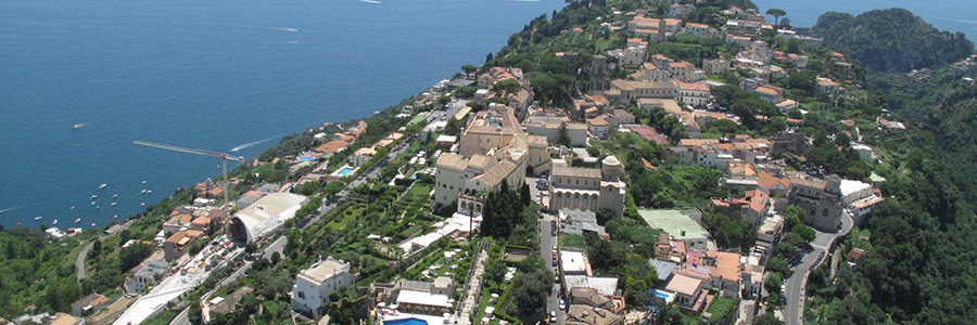
Ravello was founded in the fifth century AD. Around year 1000, a group of nobles from the Republic of Amalfi rebelled against the authority of the Doge, and moved there. The city grew rapidly since then, thanks to its intense trading activities with other parts of the Mediterranean. It reached its greatest success in the ninth century under the Republic of Amalfi and the Principality of Salerno. Ravello became a bishopric in 1086, and during the following century it remained a strong and powerful entity, having more than 30,000 inhabitants. Its economic and political decline began during the Norman period, it became dramatic during the seventeenth century and lasted until the end of the eighteenth century. This decline, however, did not affect at all its beauty: rediscovered by intellectuals and artists in the nineteenth century, it regained its importance as a place of tourism and cultural elite.
Cathedral of Ravello
Founded in 1086 by the bishop of Ravello Orso Papice, the Duomo dominates the square and presents a splendid portal with bronze bas-reliefs that was built in 1179 in Constantinople and then brought to Ravello by sea.
Villa Cimbrone
Cimbrone hosted monarchs and famous artists, scientists and politicians. The complex dates back to the Roman period, in fact it was built on the ancient foundations of a patrician villa. The lush gardens of the villa lead to the spectacular "Terrace of Infinity", whose view Gore Vidal has called "the most beautiful in the world".
Villa Rufolo
Was the city residence of the Rufolos, the most powerful noble family in this little town, whose members were bankers of the Angevin kings of Naples (XIII-XIV sec.). Its construction dates back to the thirteenth century. In the gardens of the villa the famous Ravello Festival, dedicated to Richard Wagner, is celebrated every year.
Auditorium
Designed by the Brazilian architect Oscar Niemeyer, a massive but at the same time elegant construction, it has a function room with 400 seats for concerts and art events.
The marine hamlet of Ravello is called Castiglione, and it offers a small and beautiful beach, surrounded on three sides by high cliffs. It 'a sandy beach, around 100 meters long. At the center there is a seaside facility, while on two sides there is open access. Being surrounded by rocks, the beach is only hit by sunrays in the mornings.
40 ° 38'57 "N 14 ° 36'42 "E
In the last century, almost all of the wonderful palaces belonging to the ancient families of Ravello have become hotels. These include: Rogadeo Palace in Piazza Fontana, the oldest one in Ravello, that was an Augustinian monastery from the eleventh to the nineteenth century, and today hosts the Hotel Bonadies. Palazzo Sasso, now Palazzo Avino, which was also turned into a hotel; Palazzo Confalone, today known as Hotel Palumbo; Palazzo (Villa) Rufolo in Piazza Duomo, famous for its gardens, where the most important and powerful family in Ravello lived.
Tab 12
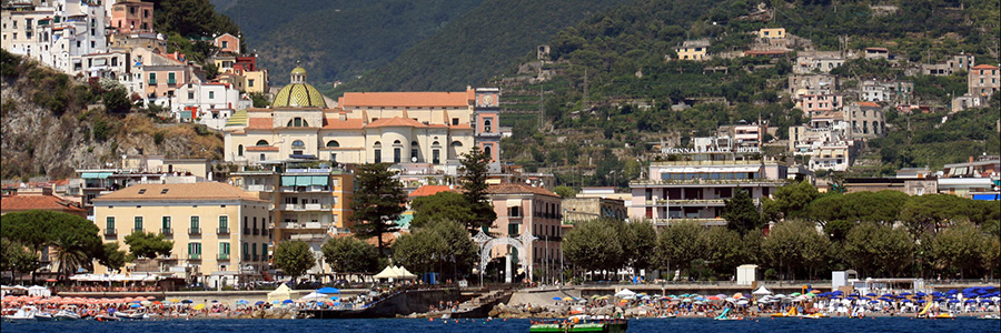
Vietri sul mare
Vietri sul Mare is the capital of ceramic art. The art of making ceramics dates back to ancient times and has been refined during the centuries; today the Vietri ceramics are considered authentic masterpieces and are known all over the world. The town is overlooked by the sixteenth century Dome of the Church of St. John the Baptist, covered by hundreds of "scandole", fish-shaped tiles of three colors: yellow, green and blue. UNESCO has declared Vietri sul Mare (together with other places of the Amalfi Coast) a World Heritage Site in 1997.
Vietri sul Mare was an ancient Etruscan coastal settlement. Later on, the site was conquered by the Samnites, the Lucani and the Romans. Like all coastal towns, Vietri had to face Saracen pirates- the watchtower located in the Marina hamlet dates back to that tormented historical period.
Its fate was linked to Cava de' Tirreni until 1806, because Marina di Vietri was used by the monks of the cava de’ Tirreni Abbey for trade purposes. From 1860 to 1927, during the Kingdom of Italy Vietri had belonged to the district of Salerno. In 1944, when Salerno became capital of Italy for a few months, King Vittorio Emanuele III made the nearby Villa Guariglia, in the hamlet of Raito, his residence. The town was severely damaged by the Allied landing (the Salerno landing) in September 1943 and by the flood of 1954, but it managed to recover economically and it currently has one of the highest incomes in Campania.
The Solimene ceramics factory
Designed by architect Paolo Soleri who drew inspiration from the Guggenheim Museum in New York; its interior encloses a large collection of contemporary ceramics.
Parish Church of St. John the Baptist
It is the widest religious building in Vietri. Built in the seventeenth century, dedicated to the patron saint of the town, it has a Latin cross shape with one nave; in the inside it contains important artistic masterpieces.
Provincial Museum of Ceramics
It opened in 1981 and it is located in the complex of Villa Guariglia in Raito, the sumptuous summer residence of Raffaele Guariglia, Italian Ambassador of the Order of Malta, as well as Foreign Minister of the first Badoglio government.
Museum "Manuel Cargaleiro"
Founded in 2003 thanks to a project of the Province of Salerno and the Portuguese artist Manuel Cargaleiro, the Museum hosts works of artists from all countries of the Mediterranean.
La Baia
It is one of the few sandy beaches of the Amalfi Coast, in addition to being one of the longest (400 meters).
La Crespella
This beach is dominated by a 16th century tower overlooking the Due Fratelli, two rocks opposite Vietri sul Mare.
Marina di Vietri
This beach was created, in one night, by the flood that hit the entire coastal strip from Vietri to Minori in 1954. Mud and debris made the beach advance by about 100 meters, creating a sandy bed that did not exist before. Today the beach is divided in two by the river Bonea.
Marina di Albori
Albori, considered one of the most beautiful villages of Italy, is part of Vietri. It is located on a hill and has a small marina connected by arduous country roads.
40 ° 40'12 "N 14 ° 43'35 "E
Between the 1920s and the 1940s, Vietri attracted many German tourists but also famous personalities such as Richard Dolker, master of Kunstwerbeschule in Stuttgart. Here they invented some original colors for the Vietri ceramic tiles that are now considered unique, like the famous Vietri yellow. The neo-romantic taste of these German artists celebrated the image of the donkey, the "ciucciariello" that still today is among the bestselling ceramic decorations.